United States Community Water System (CWS) Estimated Service Area Boundary (ESAB) Geospatial Database
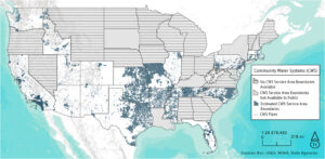
The United States Community Water System (CWS) Estimated Service Area Boundary (ESAB) Geospatial Database project sought to develop a comprehensive database of available ESAB of community water systems in the United States. The research team conducted Google searches and contacted government, water industry, and academic entities to collect all available geospatial representations of CWSs. From this research, the team identified twenty-four states and the District of Columbia as having polygons representing CWS ESAB as of December 2020. These data were harmonized to construct a national database. The primary goal of the project was to develop geospatial database that enables race/ethnicity, socioeconomic, water justice analyses at the community water system level rather than a larger unit of analysis such as municipal, county, or state-level.
Research Assistants: Kayla M. Anderson, Mariah D. Caballero, & Amy Podraza
Faculty Advisors: Dr. Doug Fisher, Dr. Elaine Hill (University of Rochester Medical Center), Dr. Yolanda J. McDonald
Student Alum: Caroline Morkel
Academic Publications:
Presentations:
- McDonald, Y. J., Anderson, K. M., Caballero, M. D., Ding, K. J., Fisher, D., Hill, E., and Morkel, C. on behalf of the Vanderbilt Drinking Water Justice Lab. Where are the community water systems? A systematic review of geospatial representation of United States community water system service areas, (presenter). University of Illinois at Urbana-Champaign Geography & GIS Colloquium, 2021, Virtual.
- Anderson, K. M. and McDonald, Y. J. Unmasking Differences: How Using the Correct Unit of Analysis in Geospatial Drinking Water Research Has the Potential to Reveal Community-Level Differences, (paper: presenter). Applied Geography Annual Conference, October 2020, Virtual.
Theoretical Frameworks:
- The Drinking Water Disparities Framework (Balasz & Ray, 2014)
- The Framework of the Components of Drinking Water Infrastructure (VanDerslice, 2011)
- The Social Determinants of Health (Marmot, 2005; Ratcliff, 2017)